Research
CISR's diverse staff and associates bring a wide range of expertise in the application of spatial methods and technology to interdisciplinary research. Some of CISR's current research themes and projects are:
Spatial Ecology of Marine Mammals, Birds, & Turtles
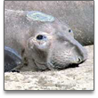 Where do marine mammals go to feed? How do oceanagraphic processes drive foraging behavior and movement? A team of researchers, led by faculty member Dan Costa, are applying advanced spatial methods to study the intersection of oceanography, species distribution, and animal behavior across multipe spatial and temporal scales. This research is focused on determining areas and characteristics of the marine environment that are important for prey acquisition, and ultimately, reproductive success, as well as, how human-induced changes in climate might affect populations of marine mammals and seabirds.
Terrestrial Predator Ecology & Conservation
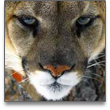 Large terrestrial predators often have disproportionately large impacts on ecosystems relative to other organisms, yet they have been vastly understudied relative to other taxonomic groups. With most large predators now in decline worldwide, a team of researchers, led by faculty member Chris Wilmers, are looking to understand the physiology, behavior and ecology of predators so as to better inform their management and conservation. This researach is focused on how climate change impacts grazer dominated food chains in Yellowstone National Park and mountain lion physiology, ecology and conservation in the Santa Cruz Mountains.
Spatial Tool Development for Ecologists
 Explicitly or implicitly, most ecological work can be given spatial axes. However, researching the fundamental effect of space in ecology remains a challenge for most ecologists and biogeographers. This is due in part to the limited availability of tools for analyzing spatially explicit ecological data in modern spatial and statistical packages. To that end, CISR is working towards developing tools for use in ESRI's ArcGIS Desktop that are designed for researchers working with and analyzing ecological data in an spatially-explicit context.
Glacial Recession in the Tropical Andes
 Glacial recession in the Cordillera Blanca (The Central Peruvian Andes) is increasing the vulnerability of human populations dependent upon glacial-fed water resources for consumption, livestock and sanitation. In conjunction with the Byrd Polar Center at Ohio State University and McGill University, a team led by faculty member Jeff Bury have been examining the rate and scale of glacier recession in the region, the effects of glacier recession on hydrological resources and the impacts of increasing hydrological variability on household vulnerability and livelihoods and adaptive management strategies.
Data Model for Botanical Gardens and Zoological Parks
 Botanical gardens and zoological parks have joined together to develop a new standard for implementing GIS as asolution for managing the spatial information associated with living collections. The Alliance for Public Gardens GIS (APGG), a partnership started by the UC Davis Arboretum and grown to a consortium of over 180 botanical gardens and zoos, is working to develop the foundation of a free and open source template for using GIS at botanical gardens and zoos called the ArcGIS Botanical Garden & Zoological Park Data Model. CISR is a significant contributor to the development of this data model.
San Francisco Child Care Information Management System
 The Low Income Investment Fund (LIIF) of San Francisco is working with the IGISc at SFSU and CISR to leverage information technology in an open and collaborative system in order to better manage child care facilities in the city and county. The project initiative delivers planning information through an internet mapping service that consists of intelligent and interactive maps and map layers. The system serves as a tool to support capacity-building, planning efforts, and the enhancement of San Francisco child care facilities.
UC Atlas: Global Inequality
 The Atlas of Global Inequality is a teaching and research tool that “explores the interaction between global globalization and inequality.” It offers maps, data, issue overviews, and bibliographies through a web-based application. The information aggregated in this database represents various social indicators, organized by nation-state, for the decades from 1960 to 2000, mostly drawn from the World Bank's World Development Indicators. The project is sponsored by the Center for Global, International and Regional Studies at UCSC and hosted by CISR.