The core of geospatial activity at UCSC takes place in the Center for Integrated Spatial Research facilities located in ISB. CISR manages both a research and teaching facility specializing in state-of-the-art spatial technology, software applications, and data. The Center also includes hardware and software for image processing and geospatial analysis, as well as a wide array of ancillary and supporting equipment.
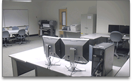
The research facility, located in ISB 450, currently supports spatial research needs for UCSC faculty, students, staff and researchers. The research facility is equipped with a range of specialized hardware and software to facilitate advanced spatial modeling, statistical analysis,and spatial database development. There is also a full complement of peripherals including field mapping equipment (survey and recreational grade GPS, laser range finder), a tablet digitizer, medium-format scanner, and a range of color and B/W output devices including a 42-inch large format printer.
The research facility schedule is regularly updated so consult the posted hours and for facility availability and procedures.
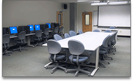
The teaching facility, located in ISB 486, currently supports academic instruction and laboratory work in spatial concepts, techniques, and methods at UCSC. The teaching facility hosts fifteen dedicated computers and peripherals configured with the latest in spatial, statistical, and cartographic software. The facility is connected to the CISR network hosting an extensive spatial data library. As a smart classroom, ISB 486 is also equipped with a computerized faculty lectern linked to a multi-resolution projection system to facilitate instruction.
The teaching facility schedule is regularly updated so consult the posted hours for facility availability and course offerings.
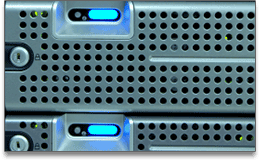
CISR hosts an enterprise grade server portfolio designed to strengthen capacity for delivering spatially-focused services, raw data storage, and computer management. Designed on virtualization technology, the Center hosts a dedicated internal network domain that provides users a homogenous computing environment, seamless access to and high availability of authorized network resources, applications, and services.
To deliver a suite of spatially enabled application and data services via the internet, the Center also hosts an array of application focused servers configured with PostgreSQL (with PostGIS), ArcSDE, ArcGIS Server, and ArcIMS.
A large suite of applications software provides state-of-the-art capabilities for image processing, mapping, modeling, statistical analysis, and visualization (click an item for more information):
- for advanced spatial analysis and modeling
ArcGIS, produced by ESRI, is a comprehensive set of GIS applications and consists of ArcGIS Desktop (with extensions 3D Analyst, Geostatistical Analyst, Spatial Analyst, Network Analyst, etc.) and the legacy commmand line ArcInfo Workstation.
- for spatial analysis and modeling
ArcView GIS 3.3 was the industry standard for desktop GIS throughout the late 1990s and is a retired product but still available and used. It was developed to complement the more powerful ArcInfo Workstation, but grew to be a relatively complete desktop GIS.
- for GIS on mobile devices, e.g. GPS or PDA
ArcPad is designed for users who require GIS capabilities in the field. It provides the ability to capture, edit, analyze, and display geographic information easily and efficiently on a GPS device or other field hardware.
- for serving basic internet mapping applications
ArcIMS is server based software that allows for centrally hosting and serving GIS maps, data, and applications for use on the Internet. It provides for the development of basic but dedicated internet applications and services.
- for serving comprehensive GIS applications via the internet
ArcGIS Server is a comprehensive server-based GIS that provides for development of rich internet applications and services for mapping, analysis, data collection, editing, and management of geospatial information.
- for serving geospatial imagery via the internet
ArcGIS Image Server extends the capabilities of ArcGIS Server by enabling dynamic mosaicking, on-the-fly processinga, and fast simplified delivery of large volumes of images from multiple sources via the internet.
- for managing spatial data in an enterprise database management system
ArcSDE technology is a core component of ArcGIS Server and enables enterprise relational database management system (RDBMS) to store spatial data. ArcSDE provides multiple GIS clients in an organization a central location to access and manage spatial data.
- enterprise database management system
PostgreSQL is an open source object-relational database management system with the feature set and reliability of an enterprise class database. PostGIS is a project which adds support for geographic objects in PostgreSQL, allowing it to be used as a repository for spatial data.
- for remote sensing and image analysis
ENVI, by ITT Visual Information Solutions, is a software for processing and analyzing geospatial imagery. ENVI provides scientifically advanced image processing and analysis capabilities including tools for pre-processing, visualization, data and spectral analysis.
- for remote sensing and image analysis
ERDAS, by Leica Geosystems, is another software for processing and analyzing imagery to enhance other GIS applications. The two main software products available are ERDAS Imagine and the Leica Photogrammetry Suite (LPS).
- for field mapping preparation and processing
GPS Pathfinder Office, by Trimble, is for preparing and using Trimble GPS and field mapping hardware. GPS Pathfinder Office enables for the pre-planning of field sessions, generation of data dictionaries, and differential correction for vastly improving the accuracy of GPS positions.
- for advanced computing, statistical analysis, and graphics
MATLAB, by The Mathworks, is a software environment for data visualization, data analysis, and numeric computation. MATLAB provides tools and functions for signal and image processing, test and measurement, statistical analysis, and computational biology.
- for advanced statistical analysis and graphics
R is an open source software environment for advanced statistical computing and graphics. R provides a wide variety of statistical (linear and nonlinear modeling, classical statistical tests, time-series analysis, classification, clustering, etc.), graphical, and spatial techniques.
- for advanced statistical analysis and graphics
SAS, developed by the SAS Institute, is an advanced statistical software and programming language used for data entry, retrieval, management, and mining; report writing and graphics; statistical analysis; applications development; and data warehousing.
- for bayesian analysis
WinBUGS is an interactive Windows version of the BUGS program (Bayesian inference Using Gibbs Sampling) for Bayesian analysis of complex statistical models using Markov chain Monte Carlo (MCMC) techniques.
- interactive 3D virtual globe
Google Earth, by Google, is a 3D interactive world viewer developed to deliver and overlay satellite imagery, aerial photography and other geographic content onto a globe. Google Earth also provides an accessible method for generating, sharing and distributing custom data.
- interactive 3D virtual globe
Nasa World Wind is an open source 3D interactive world viewer created by the NASA Learning Technologies Project. World Wind provides simple visualization tools for interacting with NASA content, including satellite imagery, SRTM data, GLOBE data, and more.
- graphic design software
Adobe Creative Suite (CS), made by Adobe Systems, is an extensive collection of graphic design and web development applications including Photoshop, Illustrator, InDesign, Dreamweaver, Fireworks, Flash, Acrobat and more.